With building information modelling (BIM) solutions from FARO quickly becoming an industry standard, it’s no surprise that FARO shapes the way teams work together to communicate, collaborate and solve problems. The result is high quality projects being built more quickly and at a lower cost.
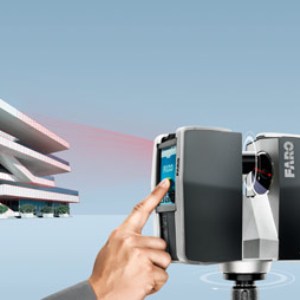
3D laser scanning with the FARO Laser Scanner aids building design at every stage of construction. With this 3D modelling tool you can compare the current 3D building status with the CAD model at any time – a quality control process which eliminates expensive and time-consuming rework.
3D scan brings the façade of the Adlon to life
-02_klein.png?sfvrsn=0 "S13062-Hotel_Adlon_(Berlin)-02_klein")
With the aid of an innovative laser scanner, the buildings and their fittings can be converted into precise three-dimensional digital models. This compact and easy-to-use device scans all visible building structures in a single run-through and then creates a precise, three-dimensional model. By generating close to one million measuring points each second, large objects and their surfaces can be captured in detail and high resolution, and even in colour.
The process is ideally suited for surveying façades, for example. The time and cost of measuring the façade grid and associated structures are reduced to a minimum with the laser scanner as, for example, no expensive scaffolding needs to be erected. This was the very process required in connection with the Festival of Lights – as a preparatory measure for a video that was to beprojected on the façade of Hotel Adlon. Spectacular light installations and animations illuminate some of Berlin’s historic buildings during the Festival of Lights. With two million visitors the festival has developed into an important economic factor. And companies appreciate the promotional value of the animations. In 2012 Volkswagen used the façade of Hotel Adlon as the background for a breathtaking promotional animation. And in 2013 too, the hotel acts as a projection surface for a three-dimensional video animation for VW. To be able to integrate the façade grid and structures into the video installation, the artists needed a precise, three-dimensional surface model with a scale of 1:10 to prepare for the event building structures in a single run-through and then creates a precise, three-dimensional model. By generating close to one million measuring points each second, large objects and their surfaces can be captured in detail and high resolution, and even in colour.
The process is ideally suited for surveying façades, for example. The time and cost of measuring the façade grid and associated structures are reduced to a minimum with the laser scanner as, for example, no expensive scaffolding needs to be erected. This was the very process required in connection with the Festival of Lights – as a preparatory measure for a video that was to beprojected on the façade of Hotel Adlon. Spectacular light installations and animations illuminate some of Berlin’s historic buildings during the Festival of Lights. With two million visitors the festival has developed into an important economic factor. And companies appreciate the promotional value of the animations. In 2012 Volkswagen used the façade of Hotel Adlon as the background for a breathtaking promotional animation. And in 2013 too, the hotel acts as a projection surface for a three-dimensional video animation for VW. To be able to integrate the façade grid and structures into the video installation, the artists needed a precise, three-dimensional surface model with a scale of 1:10 to prepare for the event. The FARO Laser Scanner provided the digital data required for the exact modelling of the hotel façade within a few hours. The surveying work took place at night so that the hotel operations and traffic would be disrupted as little as possible. Three scans were made on the roof of the building opposite at a distance of 60 metres from the Adlon, six further scans from the road at a distance of some 30 metres and a six more ten metres away from the façade.

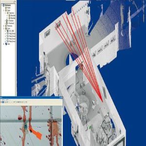
“With the 15 highresolution individual scans, we generated approx. 2,400,000,000 measuring coordinates,” Lars Sörensen, managing director of the Berlin consultant company Scan3D, explained. “More than enough to map out each and every façade detail exactly.” The scan data was then imported directly into the application LupoScan where the individual scans could be referenced on the basis of target marks. The application Rhinoceros was then used by the surveyors to model the façade surface. “That was necessary because we couldn’t use a forklift to position the scanner because of the location,” Sörensen said. As such, an extremely precise digital surface model was created, which was then used by the model builder. With the aid of the 1:10 model, the video artists were able to tailor their 3D animation precisely to the façade structure and target the hotel façade exactly with the projectors.
3D documentation of the magnificent glass roof of Leicester University Engineering Building
As-Built Documentation / Architecture Digital measurement using FARO Laser Scanner FOCUS3D Data collection with the latest generation of 3D laser scanners is now easy, accurate and rapid.
3D SurveyScan LLP acquired a Faro Focus3D in December 2011. They realised a potential in the market to offer a service using the scanner in various industry environments. 3D SurveyScan was amazed as to how little these industries knew of 3D scanning and point clouds. Even today, people from all industries are just beginning to realise the potential of using scanning to assist them in their day-to-day projects. Especially as BIM (Building Information Modelling) is the way the government is pushing the industry forward with revit being the choice of software to model in. Before measurements would have been carried out by disto and tape measure. “The package 3D Surveyscan is offering is very flexible from providing a basic point cloud for the client to use themselves to model. Or we can give them the whole package including modelling services” states Ron Smith, co-owner of 3D SurveyScan LLP. So far 3D SurveyScan has produced quality packages for varying markets. Ranging from private dwellings, retail outlets providing floor and ceiling plans, to National Grid pumping stations, to office buildings including ceiling voids and heritage work.

Measuring of a museum

“Our task was to create a complete Building Information Management system as soon as possible, so that planning and construction work will be based on reliable information. To do this, we deployed teams working in two eight-hour shifts. One team was on site scanning with a FARO Focus3D laser scanner while the other team was processing the point cloud data. Work began on the 19th November and scanning was completed on the 20th December 2012,” explains CEO International Partner Buro, Marian Radoi.

Bringing accurate survey results with FARO Focus3D

 The West Tower was laser scanned using a FARO Focus3D which captured the complex structure with ease and speed. The scan data was tied to the on-site control framework using total station control. The data was processed in Faro Scene software to create a single registered point cloud of the basement up to the upper tower level.
The scan data was used to create an accurate Revit Model of the West Tower to provide sufficient detail to the Project Architect to help design and plan the complex abutment of the proposed new stadium to the Tower. The existing foyer design is extremely complicated and surveying by other means would have been virtually impossible.
We have been using laser scanning for many years and use this technique on most of our measured building survey projects. The speed and the ease of use of the FARO Focus3D enabled us to record interior spaces rapidly and accurately reducing time on site, says Jenny Clark, the Director of 3D Surveying at Mollenhauer Group. “Another main advantage was the ability to publish the scan data on FARO Webshare (at no additional cost) to enable the client to view and share the data”.