| Leica MobileMatriX directly integrates survey related data collection and processing functionality into ArcGIS®. Leica MobileMatriX can be used in field and in the office, providing a consistent, intuitive user interface. Furthermore, it is no longer required that the survey data is processed in an external software since Leica MobileMatriX integrates all data processing within the GIS. Leica MobileMatriX is the perfect software for feature data collection and management and computation and storage of survey data based around the geodatabase from ESRI. |
Leica MobileMatriX is available in three editions: Standard, Professional and on ArcGIS®.
The Leica MobileMatriX Standard Edition software is ideal for typical data collection tasks. With a simple user interface based on Leica Geosystems and ESRI interface design, you can collect point, line, or polygon features including attribute information with high performance and productivity.
The Leica MobileMatriX Professional Edition software offers everything that the Standard version offers, and furthermore it supports disconnected editing technology from ESRI, the complete ArcGIS® database model and many more features. It is ideal for data maintenance tasks – disconnected from the network environment with the ability for in the field data collection and design using the checked out features – especially for companies working with an ESRI enterprise database in the office.
The Leica MobileMatriX on ArcGIS® Edition runs as an extension on any ESRI ArcGIS® Desktop product (ArcView, ArcEditor, ArcInfo) with version 10.0 / 10.1 providing:
- Full GIS functionality of underlying ArcGIS Desktop available.
- GIS functionality varies according to ArcGIS Desktop product.
The usage of ArcGIS® as platform for Leica MobileMatriX ensures a seamless dataflow between field and office and vice versa. Quality and completeness control is moved from office to field, complex and cost-intensive data conversion, as well as data redundancy is avoided with Leica MobileMatriX.
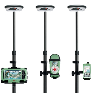
Collect and manage spatial information, make measurements in the field to create and update maps, plans and databases suitable for:
|