FARO® SCANPLAN FOR FAST 2D FLOOR PLAN MAPPING
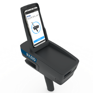
FARO® ScanPlan, an innovative, handheld device that dramatically speeds up the process of capturing 2D floor plans. It is an ideal tool for anyone who needs to quickly obtain as-built floor plans of buildings for threat assessment, pre-incident planning and fire protection engineering, 2D as-built documentation, or optimal scan job planning. Use the ScanPlan to document floor plans of buildings large and small, including houses, schools, shopping malls, public venues, office buildings, construction sites, and more.
Just point and walk to capture a current 2D floor plan of any building. Control the ScanPlan with an easy-to-use smartphone application (Android or iPhone) that shows the floor plan map as it is being captured in real time. The wide-angle field of view makes it easy to map around corners, behind doors, and other hard-to-reach areas. Users can even take photographs and map multiple-story buildings, keeping the floors organized as one project. The visual interface makes it easy to confirm that everything needed to be mapped is completed before leaving the site or the building.
Bring the captured building map into FARO Zone 2D software to complete the project. Turn the floor plan into a detailed pre-incident plan or threat assessment diagram by adding photographs of critical details, standard symbols, notes, measurements, and more.
Provide stakeholders access to captured information via SCENE 2go & SCENE WebShare Cloud or Present4D VR Suite.
Easily export projects, images and documents as DXF, PDF or into a Esri Shape file for use in GIS systems, export the 2D map as point cloud into CPE, PLY and XYZ.