Carlson Civil 2016 is here — look for a complete civil engineering software featuring‘Fair Price. Full CAD. Free Support!’ Joining 2015’s focus on 3D features, the new Carlson Civil 2016 release delivers support for AutoCAD® 2016 and the all-new IntelliCAD®8.1, plus enhanced collaboration options.
These include the new Settings Server, which enables CAD managers to easily distribute uniform command settings and files to Carlson users throughout their company. And, there is added support for the Subversion (SVN) server and the Bentley ProjectWise for additional “cloud” coordination for project data with Carlson Data Depot
Carlson Civil is the civil engineering design software that puts you in the passing lane! What might take days with other civil engineering software takes just hours, or even minutes, with the powerful and intuitive Carlson Civil–it’s advanced technology that will work for you.
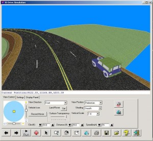
Get road design with textures, lane stripes and vehicle motion in Carlson Civil
Work with Carlson Civil on AutoCAD (versions 2010 to current) or with the built-in IntelliCAD 8.1. With Carlson Civil, you’ll get true 3D, easy-to-use 3D, plus, with the updated 3D Flyover, any surface edits made in CAD are automatically updated in the 3D view.
Road NETwork. Build all roads, intersections and cul-de-sacs in 2D and 3D with a single click of the “PROCESS” button.
SiteNET. Elevate your estimating accuracy with this intuitive layer-based surface generator and earthwork calculator.
LotNET. Quickly define an entire subdivision of lots based on an outer boundary, interior ROWs or Centerlines, and a simple set of user-defined “rules,” then pick “PROCESS” and the lots appear, defined and labeled.
Carlson Civil is one component of the Carlson Civil Suite and is designed especially for civil engineers and CAD technicians who need power and flexibility to make “short work” of even the most challenging design projects. At its foundation, Carlson Civil contains sophisticated and integrated command sets that are easy to learn, cost-effective and even fun to use!
Carlson Civil users have an extensive selection of analysis and design tools at their fingertips, including these favorites:
- Road NETwork – Use it for the design of streets, highways, roadway intersections, Cul-de-Sacs, traffic circles and more!
- Lot NETwork – Design and layout of tracts of land including residential subdivisions, office parks and commercial property development projects!
- Site NETwork – Automate the tasks of subgrade design, takeoffs, cost-estimating and surface model generation and migrate this data to GPS-assisted machine control products including Carlson Grade!
- Design Pad Template – For complex grading scenarios involving foundation pads, drainage basins, parking lots and more!
- Project Setups – Flexible data and settings storage
- Data Compatibility – Supports industry stand LandXML, plus specific data conversion
CAD Standards:
- Draw Standard Items: Create common CAD entities with pre-defined properties
- Settings Explorer: Manage all program settings from single interface
- Settings Libraries: setup tables for symbols, layers, road templates, etc.
- Data Depot: Document management for workgroups and archiving
- Project Sub-Folders: Custom controls of data folders by type