Carlson GeoTech provides the ability to import borehole data for analyzing subsurface conditions and materials.
“GeoTech will model all core samples and produce a detailed, easy-to-read report for drill logs, cross sections, and plan view,” says Dave Carlson, V.P. of Development for Carlson Software.
In addition, this information is fully integrated with Carlson Civil, for determining site stability and suitability, and also Carlson Construction, for accurate strata takeoff estimation.
Carlson GeoTech supports AutoCAD® and comes with IntelliCAD® built-in. This is in addition to working on legacy AutoCAD versions.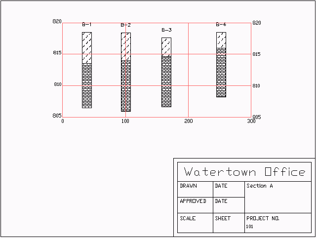
Developed over the past 10 years within Takeoff, Carlson’s popular site estimating and data prep software, Carlson GeoTech joins Carlson CADnet and Carlson Trench to be paired with Carlson Construction to form the all new Carlson Takeoff Suite, replacing the non-OEM version of Takeoff. (Note: Carlson Takeoff with built-in AutoCAD remains the same.)
“These modules serve to answer the specific needs of geotechnicians, civil engineers, and construction professionals who may not have required all of Takeoff’s many capabilities,” says Todd Carlson, product manager for Takeoff.
Features :
Key Capabilities
– Input and edit drillhole log data with strata elevation, depth and attribute data
– Generate drillhole log reports
– Label drillholes
– Draw Geologic Columns
– Draw Fence Diagrams
– Draw Isopach Maps for strata thickness, elevation or attributes
– Draw Strata Surfaces
– Draw Strata Depth Contours and Cut Color Maps
– Model Strata Surfaces with linkage to Carlson Civil and Construction for strata quantities
– Annotate plan view drillhole location maps
General
-
-
Built on AutoCAD and IntelliCAD
Carlson GeoTech will run in AutoCAD®, versions 2010 to current, as well as AutoCAD® Map, Land Desktop and Civil3D and also on IntelliCAD.
-
Allows users to do the following:
–Input and edit drillhole log data with strata elevation, depth and attribute data–Input and edit drillhole log data with strata elevation, depth and attribute data
-
Drawing Cleanup
Fix common drafting errors
-
Drafting Enchancements
Handy tools for working in AutoCAD® such as Join Nearest, Shrinkwrap Entities, Polyline Utilities, Drawing Inspector, Layer Inspector and Twist Screen
-
Data Compatibility
Supports industry standard LandXML and scores of specific data conversions
-
Surfaces
-
-
Build Surfaces
By triangulation or rectangular grids
-
Contouring
One step triangulate and contour from 3D entities as well as contouring from surface files
-
Surface Manager
Change surface display properties and adjust surface functions to add and remove points and breaklines and swap edges
-
Volumes
Earthwork volumes between triangulation or grid surfaces
-
Pad Design
Tie cut/fill slopes from pad perimeter to surface, build pad surface, calculate and balance volumes, and edit pad parameters
-