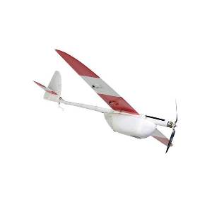
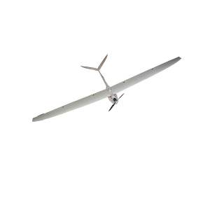
The Aeromapper Talon offers the easiest way to achieve professional georeferenced DEMs and orthomosaics. Features a very strong EPO foam body with internal carbon fiber reinforcements, parachute landing system, 24 Mp camera with survey grade lens (the best optics for UAV mapping), fully autonomous flight, handlaunch (no launcher required!). Also includes long range control and long range data link (20kms). All units are delivered flight tested and ready to fly. Camera is installed in panoramic orientation for most optimal area coverage with maximum side overlap.
Othomosaics of up to 1.5cm/pixel resolution are easy to achieve thanks to its low speed and incredible stability. It delivers georefenced imagery.
No experience or training is required.
Ideal for confined areas or difficult terrain: its amazing climb angle of more than 45 degrees, plus its unique abilty to safely deploy the parachute at very low altitudes and its automatic terrain followingmakes the Aeromapper Talon the top choice for those difficult missions.
System includes:
- Aeromapper Talon UAV ready to fly and flight tested
- Parachute system installed & ready to use
- Sony a5100 24Mp camera, Voigtlander lens and lens adaptor
- Handheld controller with long range system (+50km range)
- Flight batteries for 80 mins of flight. Additional batteries can be purchased separately
- Telemetry modules (915 Mhz, +20 kms range)
- Lipo battery charger & Lipo monitor
- Carrying case with custom cut foam
- Full Instructions Manual with tons of pictures, examples and step by step instructions for your first flight and survey missions. No training necessary.
- Mission Planner & full instructions to create survey missions and use as Ground Control Station
- Just add your laptop of choice
AREA COVERAGE CHART
| GSD (ground resolution) | Altitude AGL (meters) | Area coverage per flight |
|
2.21 cm/pixel |
85 m |
4 km2 |
|
3.25 cm/pixel |
125 m |
6 km2 |
|
6.50 cm/pixel |
250 m |
11.6 km2 |
|
10.4 cm/pixel |
400 m |
18 km2 |
|
15.6 cm/pixel |
600 m |
25 km2 |
– Area coverage per 80min flight, including takeoff and recovery flight time. Larger areas can be covered in several flights in the same day.
– Calculated with 30% side overlap
– Calculated using the standard 24 Mp camera & lens provided
– For 3D terrain models side overlap must be minimum 60%, reducing estimated area coverage per flight