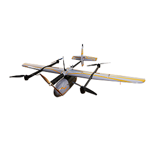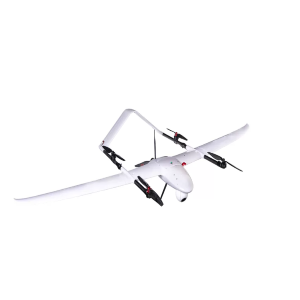
P330 PRO
Long-endurance VTOL drone for surveying and mapping
HIGH EFFICIENCY. LONG ENDURANCE
150 mins endurance and up to 20 km² coverage per flight
The P330 Pro VTOL drone is characterized by an ultra-efficient aerodynamic design and can reach 150 minutes of endurance with its payload to cover large areas per flight. With advanced power management and superior navigation algorithms, the P330 Pro can accurately map a region of 20 km² at a scale of 1:2000. Mapping highway corridors and surveying open-pit mines are now within reach in a single flight.
TRUSTED BY AERIAL SURVEY SPECIALISTS
Triple redundant flight control system and safer operation
The P330 Pro is packed with the latest aviation technologies. A dual GNSS system, a triple IMU system, dual antenna positioning and orientation, 5 safe return to base strategies, and 9 safety monitoring checks guarantee safe flight operations and reliable aerial survey results.
REDUCE OPERATING COSTS AND SAVE TIME
No more systematic ground control points (GCP) required
The P330 Pro integrates a high-accuracy GNSS RTK / PPK module that has up to 100 Hz differential data update rate. With its advanced GNSS PPK data processing and photogrammetry software, the final mapping results are accurate to the centimeter level. Avoiding the establishment of ground control points can also save up to half of the time required for the project. Faster data acquisition with a smaller field crew significantly increases the return on investment of the mission.
SWAPPABLE AIRBORNE SENSORS
Switching cameras in the field is fast and simple
The P330 Pro is not only available with an orthophoto camera for producing orthophoto maps, but also with optional sensors, such as an oblique camera for 3D modeling applications, to address the most demanding mapping and topographic surveys. The load bay design supports a wide range of sensors, including orthophoto cameras, half-frame and full-frame oblique cameras, medium-frame cameras, multispectral cameras, or lightweight laser scanners, and the ability to quickly switch between them.
OVERVIEW
The P330 Pro is a high-performance vertical takeoff and landing (VTOL) fixed-wing unmanned aircraft system (UAS), specially designed for aerial surveying and mapping applications. With its concept of high accuracy, long-endurance, and multiple payloads, it meets the requirements of mapping and aerial surveying professionals for many different applications.
The P330 Pro UAV allows you to conduct small- and large-scale aerial surveys with extreme data quality and cost savings at a significant time. It is an alternative to manned aircraft for surveying and mapping, mining, construction and infrastructure, environmental monitoring, agriculture, etc.