Introduction
The Viking Navigation software package has a very rich and long history, and is built on long experience. For many decades our Viking Software has already served on a multitude of vessels and industries all over the world.
Viking Navigation is targeted for use in all professional nautical industries, which include offshore, dredging, hydrographic survey, commercial fishing and marine construction.
Features Overview:
- Advanced graphical Ship Designer
- Built in vector chart editor
- DXF Support
- Extensive navigation track
- Instant marker tool
- Local chart projection support
- Navigation simulator
- Navionics chart database interface
- Night-, dusk-, and sun display modes
- NMEA navigation devices support
- Print to any printer on A4 to A0 paper size
- RS232, RS422 & RS485 Physical & Virtual comport support
- Track playback feature
- Viking Modules expansion interface
- Viking ODIN chart format import
- Worldwide chart datum support

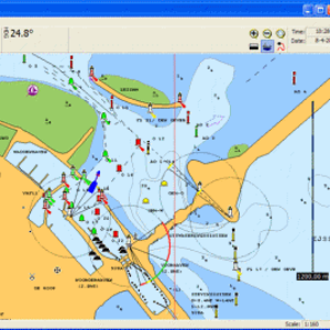
Offshore navigation showing North Sea oil platforms
Ease to use:
Viking can connect to virtually any GPS receiver and compass device, providing a solid base for every navigation requirement.
By providing a clean and simple user interface Viking can be accustomed to in just a few minutes. The tools most often used can be found directly on the screen, and by using the menu bar all further functions are easily accessed.
Viking provides extra sidebars for more directly visible and ready to use tools. The sidebars can be turned on and off, any time when needed, by a simple keypress.